 Information gathered by the Lake Ontario Coastal Initiative - LOCI is a partnership of the Center for Environmental Information (CEI), Finger Lakes-Lake Ontario Watershed Protection Alliance and SUNY Brockport, dedicated to protecting New York's Lake Ontario coastline - shows that phosphorus has a greater impact on coastal areas of Lake Ontario than on offshore areas. Pollution prevention efforts have improved offshore water quality, but coastal areas have not seen the same improvements.
In 2009, the Great Lakes Commission (GLC) received a $254, 695 American Recovery and Reinvestment Act (ARRA or Stimulus) grant from DEC for water quality planning that will help DEC develop phosphorus Total Maximum Daily Load (TMDL) plans for several tributaries to Lake Ontario. GLC worked with CEI to carry out this project.
Because DEC and the Environmental Protection Agency have not yet designated a maximum amount of phosphorus that is allowable in the lake's tributaries, full TMDLs could not be developed with this grant. Instead, DEC requested that GLC develop Water Quality Restoration Strategies (WQRSs) for the tributaries.
The WQRSs:
- describe the current levels and sources of phosphorus;
- provide guidance for watershed planning and implementation of measures to restore water quality.
The WQRSs will help DEC account for point and nonpoint sources, and natural background levels of phosphorus as TMDLs are developed. The WQRSs and eventual TMDLs will help guide efforts to address water quality problems in the tributaries and coastal sections of Lake Ontario.
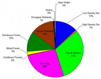
Percentage of land use in the Lower Black Creek Watershed.
Characterization of watersheds is one of the first stages of WQRS
and TMDL development. This chart is part of the WQRS
for Lower Black Creek, available on CEI's website.
 GLC, working in partnership with CEI, finished work on this project in December, 2011. The WQRSs for three tributaries to Lake Ontario - Upper Black Creek, Lower Black Creek, and Upper Oak Orchard Creek - were completed.
GLC began by compiling information about sources of pollution, including phosphorus, and characterizing five watersheds that flow into Lake Ontario:
- Upper Black Creek
- Lower Black Creek
- Upper Oak Orchard Creek
- Mill Creek
- Shipbuilder's Creek
All of these stream segments are on the DEC Priority Waterbodies List and have been identified as impaired by excessive nutrients, especially phosphorus.
GLC also created watershed maps for Black Creek and Oak Orchard Creek, and conducted stream monitoring in the Black Creek, Shipbuilder's Creek, and Mill Creek watersheds. The stream monitoring measured the current condition of these streams, including phosphorus and nitrogen levels, and attributes such as temperature, pH, and dissolved oxygen levels. The monitoring data has been included in data reports created for each of the watersheds.
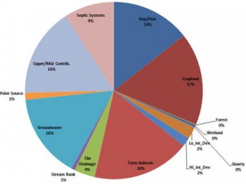
Sources of phosphorus in the Lower Black Creek Watershed, as
established by the water quality model developed for this project.
This chart is part of the WQRS for Lower Black Creek,
available on CEI's website.
The watershed and phosphorus information helped GLC create computer-based watershed water quality models for Upper Black Creek, Lower Black Creek, and Upper Oak Orchard Creek. The models were used to identify sources of phosphorus and test the effectiveness of various management options, or Best Management Practices (BMPs), that could be used to reduce phosphorus levels in Lake Ontario's tributaries.
Draft WQRS reports were developed for the Upper Black Creek, Lower Black Creek, and Upper Oak Orchard Creek watersheds. The reports detail the data collection and evaluation process and include a list of BMPs ranked by cost effectiveness. After the draft reports were published for public review and comment, the public comments were assessed and the watershed models were adjusted. The WQRSs were then finalized and made available on CEI's website.
Final WQRSs, data reports, and fact sheets describing water quality in Black Creek and Oak Orchard Creek, along with the process for developing WQRSs and TMDLs, are on the CEI website. A direct link to CEI's Lake Ontario Basin TMDL Project web page is in the "Links Leaving DEC's Website" section of the right-hand column of this page.
When each ARRA 604(b) project is complete, DEC requires a final report summarizing the entire project to be submitted. The report includes a description of the project's goals, work accomplished, and final project outcomes.
YOU MIGHT ALSO LIKE
Share this Post
latest post
-
 Turnip Rock Lake Huron June 30, 2023
 -
 Lake Erie Captains January 30, 2023
 -
 Lake Superior Minnesota December 31, 2022
 -
 Lake Ontario Sturgeon December 1, 2022
 -
 National Park on Lake Erie November 1, 2022
 -
 Lake Erie frozen Foods October 28, 2022
 -
 Lake Erie Dental Erie PA October 27, 2022
 -
 Eagle Lake Ontario fishing Reports October 26, 2022
 -
 Lake Ontario beaches October 21, 2022